Strategic land use planning that moves projects from concept to approval — on time and on budget.

At Evergreen Design Group, our land planners bring 21 years of experience translating complex site conditions, zoning requirements, and client objectives into clear, actionable Conceptual Site Plans (CSPs). We work nationally alongside land developers, civil engineers, and architects — functioning as a seamless extension of your project team from first site assessment through municipal approval.

Land-Use-Planning-Services

What Are Land Planning Services in Landscape Architecture?

Land planning — also called land use planning or site planning — is the foundational process that determines how a site will be organized, developed, and regulated before detailed design begins. It integrates zoning analysis, environmental assessment, infrastructure placement, and land use strategy into a coordinated site plan that guides every subsequent design decision.

For developers, architects, and civil engineers, a well-executed land plan is the difference between a project that moves confidently through municipal review and one that stalls in costly redesigns and regulatory delays. Land planning operates within the framework established by Authorities Having Jurisdiction (AHJs) — the local and state agencies that define permitted uses, densities, and development standards for a given site. Understanding those requirements before design begins is what keeps projects on schedule and on budget.

At Evergreen Design Group, our land planners bridge the gap between your project vision and approval-ready documentation — researching regulations, evaluating site constraints, and producing illustrated site plans that communicate clearly to municipalities, engineers, and contractors alike.

Site Analysis and Land Use Planning

Land planning designs

A successful land planning engagement begins with a comprehensive site analysis — the foundational step that separates projects that move efficiently through entitlement from those that encounter costly surprises mid-process. At Evergreen Design Group, our land planners collaborate with civil engineering partners to examine every aspect of the site: topography, soil conditions, hydrology, existing infrastructure, utility access, and environmental constraints.

This detailed assessment allows us to identify both opportunities and limitations early — before design decisions are made that are difficult or expensive to reverse. By understanding the full picture of existing site conditions, we help developers, architects, and civil engineers determine the most viable land use configuration for residential, commercial, mixed-use, or civic projects.

The result is a site analysis that doesn’t just describe what’s there — it informs every subsequent planning and design decision with data your entire project team can rely on.

Regulatory Compliance in Land Planning

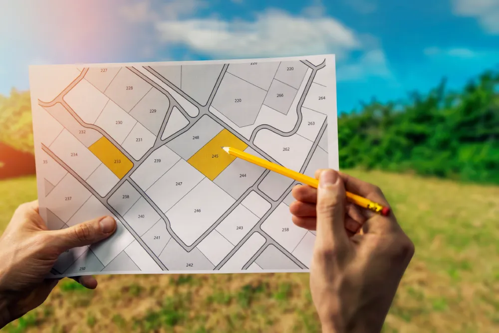
Regulatory compliance isn’t a final checkpoint — it’s a thread woven through every phase of sound land planning. At Evergreen Design Group, our land planners conduct proactive due diligence on zoning ordinances, subdivision regulations, buffer requirements, and environmental laws at the local, state, and federal levels before design work begins.

This upfront investment in regulatory research is what keeps your project out of costly revision cycles. We identify potential conflicts early, coordinate with municipal contacts when needed, and structure our Conceptual Site Plans to align with the specific approval requirements of your jurisdiction — giving reviewers what they need to move forward with confidence.

For developers, architects, and civil engineers, that translates directly into fewer delays, reduced entitlement risk, and a cleaner path from concept to construction.


Our Land Planning Process: 5 Steps to Approval-Ready Site Plans

Every land planning engagement at Evergreen Design Group follows a structured, client-focused workflow designed to eliminate surprises and keep your project timeline intact. The process involves understanding different types of land and data collection methods, including the use of aerial photography to capture images of the earth’s surface for mapping, landscape analysis, and detecting environmental changes.

1. Zoning Research &
Regulatory Due Diligence

Before a single line is drawn, our land planners conduct a thorough review of local zoning ordinances, building codes, buffer zone requirements, and environmental regulations applicable to your site. Due diligence and research also include reviewing existing zoning, property lines, deed restrictions, and easements. Understanding these constraints upfront prevents the redesigns and approval delays that derail projects and budgets.

2. Site Feasibility Analysis &
Stakeholder Meetings

We work directly with land developers, architects, civil engineers, and municipal contacts to assess a project’s viability. Site selection and feasibility analysis involves evaluating the land’s potential through surveys, topography analysis, and checking for environmental constraints and utility access. This phase identifies key site constraints — access points, setback requirements, floodplain boundaries, environmental considerations — and weighs them against your development objectives. We factor in regional planning trends and growth patterns to ensure the plan supports long-term investment value.

3. Conceptual Site Plan (CSP) Development

Our land planners produce illustrated CSPs — available as detailed 3D renderings or freehand conceptual drawings — that visually communicate the full proposed site layout, including:

  • Building footprints and placement
  • Vehicular and pedestrian circulation, parking, and access points
  • Landscape, open space, and green infrastructure zones
  • Stormwater drainage and utility corridor considerations

A clear, well-illustrated CSP aligns your entire project team and gives municipal reviewers the clarity they need to move forward confidently.

4. Live Collaboration & Remote Review

Evergreen Design Group’s remote-first collaboration model allows clients anywhere in the country to review and respond to live CSP updates via screen-share sessions. This accelerates decision-making, reduces revision cycles, and keeps projects moving — regardless of geography. Efficient permitting is supported by navigating local, state, and federal regulations to secure approvals faster.

5. CSP Refinement, Finalization & Handoff

We refine the CSP through client review cycles until the plan is fully approved and ready for the next phase. The finalized deliverable includes a color-coded, fully annotated site plan with land use data, zoning compliance documentation, and clear site specifications for your engineering and construction team. The regulatory approval and permitting phase involves navigating zoning, obtaining permits, and potentially adjusting designs based on public hearings or agency feedback.

A finalized CSP is just the beginning of what Evergreen Design Group can deliver. As your project moves from entitlement into detailed design, our team can provide continuity across every subsequent phase — eliminating the coordination gaps that slow projects down when multiple consultants are involved.

What comes after the CSP:

  • Risk mitigation — Environmental, legal, and engineering constraints identified early reduce unexpected costs downstream
  • Infrastructure coordination — Site plans aligned with planned utility corridors and road improvements to minimize infrastructure costs
  • Environmental analysis — Constraint evaluation and compliance documentation for agency review
  • Feasibility support — Land use configurations optimized for density, marketability, and return on investment
  • Full landscape architecture services — Planting plans, irrigation design, hardscape, and community amenity design handled by the same team that planned the site


Land Planning Services by Project Type

Our land planning experience spans a broad range of development types — each with its own regulatory framework, site demands, and approval pathway. Every engagement is approached on its own terms, with plans tailored to the specific zoning environment, site conditions, and project objectives at hand.

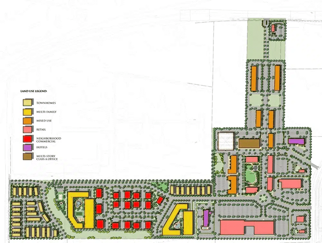
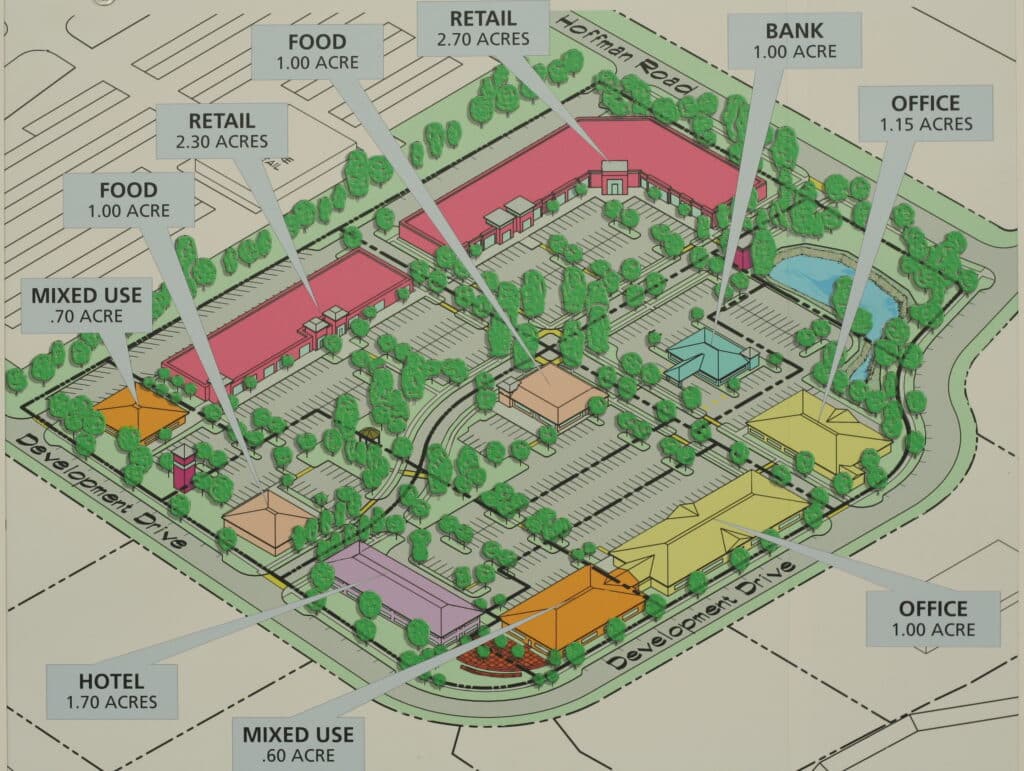
Commercial and Mixed-Use Developments

For retail centers, office parks, restaurant pads, and mixed-use properties, our land planners optimize site organization around pedestrian flow, parking ratios, ADA accessibility, and commercial visibility — supporting both business operations and the customer experience your tenants require. Zoning regulations play a critical role in determining site organization, building placement, and permitted uses for commercial and mixed-use developments. Zoning and land use regulations dictate what can be built, the density, and the permitted use of land.

Residential and Multi-Family Communities

We develop regulation-compliant site plans for single-family subdivisions, townhome communities, and multi-family developments. Our residential land planning process addresses internal circulation, lot yield optimization, open space requirements, stormwater management, and community amenity placement — all structured to satisfy municipal approval requirements while maximizing the development’s long-term market value. Whether you’re entitling a 20-lot infill subdivision or a 500-unit master-planned community, we tailor the plan to the specific regulatory environment and market context of your project.

Public, Civic & Institutional Sites

For parks, recreation facilities, schools, and public-serving institutions, we develop site plans that prioritize ADA-compliant accessibility, intuitive wayfinding, and flexible-use programming — all within the specific regulatory frameworks governing public projects.

Industrial & Institutional Development

We support industrial, warehouse, and institutional project teams with land plans that address functional site organization, heavy vehicle and equipment circulation, utility infrastructure coordination, and code compliance — structured to meet the rigorous review standards of municipal and state agencies. Our plans give your engineering and construction team a clear, coordinated framework to build from.

Why Project Teams Choose Evergreen Design Group for Land Planning

Land planningNational reach, local knowledge. Our landscape architects are registered in 40+ states, giving us direct familiarity with the regulatory environments where your projects are located — from Florida to California, Texas to New York.

21 years of project experience. Since 2005, we’ve delivered land planning services on commercial, residential, mixed-use, and civic projects across the country. Our process is refined, our turnaround is reliable, and our plans are built to survive agency review. We are committed to conserving natural resources and promoting smart growth principles in all projects, ensuring that land use planning supports both environmental and economic goals.

Integrated service capability. Land planning is the starting point. When your project moves into detailed design, our team can continue with landscape architecture, planting plans, irrigation design, and community amenity design — maintaining continuity and eliminating coordination gaps between consultants. Our approach integrates sustainability and green infrastructure strategies, such as permeable surfaces and green roofs, and includes planning for green-friendly transportation and energy use to support sustainable urban development.

Client-first communication. We work the way your team works — remote collaboration, responsive communication, and clear deliverables at every phase. You make the decisions; we provide the expertise and the documentation to support them.

Frequently Asked Questions

Land planning is the pre-design phase that establishes how a site will be organized and used, addressing zoning, access, building placement, and regulatory compliance. For example, a land plan for a new residential community will determine the arrangement of streets, lots, open spaces, and amenities to ensure efficient land use and compliance with local codes. Site planning and design then provides detailed, site-specific design for residential, commercial, or industrial projects, refining the layout and preparing for construction. Landscape architecture encompasses the detailed design of outdoor spaces — planting, grading, hardscape, irrigation — that follows once the land plan is established. At Evergreen Design Group, we provide both.

A Conceptual Site Plan is an illustrated plan drawing that depicts the proposed layout of a development site, including buildings, parking, circulation, open space, and key infrastructure elements. CSPs are used to communicate the project concept to clients, municipalities, and project team members before detailed engineering and design begins.

Yes. Evergreen Design Group provides land planning services nationally. Our landscape architects are licensed in 40+ states, and our remote collaboration model makes geography a non-issue for project communication and delivery.

Timeline varies by project complexity, site conditions, and municipal review requirements. We establish clear milestones at project kickoff and manage our workflow to meet your schedule. Contact us to discuss your specific project and timeline.

Start Your Land Planning Project Today

Whether you’re a developer evaluating site feasibility, an architect looking for a land planning partner to join your project team, or a civil engineer who needs a coordinated CSP to support permitting, Evergreen Design Group is ready to engage.

We deliver approval-ready land plans on time — backed by 21 years of national experience and licensure across 40+ states.

Get in Touch with Us

Ready to move your project forward? Tell us about your site and a member of our land planning team will follow up promptly.